 and Salzburg (Austria) during heavy rain in January 2016")
David Crawford looks at new technologies to cope with the age-old problem of driving in bad weather.
On the 10-year average, between 2005 and 2014 bad weather contributed to more than 1.5 million vehicle crashes in the US each year, resulting in more than 800,000 injuries and 7,400 deaths. These were the findings of analysis by
An analysis by USA Today, published in its edition of 4 March 2015, showed that there had been at least 54 pile-ups of 10 vehicles, all weather related, over the winter since the Thanksgiving holiday the previous November - and concluded that the trend was on the rise. In addition, US drivers experience over 500 million hours of delay due to fog, snow, and ice; and trying to catch up time afterwards can add a further level of risk.
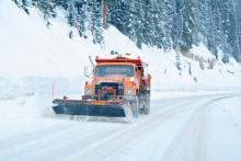
In Europe, some 30% of road traffic crashes are weather -and environment-related, and result in some 8,000 deaths a year. Even with recent innovations in steering, traction and braking systems, drivers continue regularly to face dangerous weather-related road conditions.
But attempts to reduce the carnage by giving drivers more effective warnings of conditions lying ahead of them have long faced a number of obstacles. One is the fact that conventional road weather forecasting has evolved largely to support highway agencies in their winter maintenance programmes, with little consideration being given to the need to represent prevailing conditions for individual drivers.
In April 2016, US weather radar showed snow falling over New England and New York State, with air temperatures below freezing. But RoadWX computed that the surface temperatures were above freezing and predicted wet roads throughout the region, verifying its information by images obtained from traffic camerasAnother is cost; conventional infrastructural sensors are too expensive to deploy across entire road networks at the necessary density – currently they can be as far as 400km apart on major roads in the US. Transportation agencies and strategic network operators tend to deploy their road weather information system (RWIS) stations at points where they expect the most trouble, leaving the surrounding roads relatively poorly represented.
Not least, station owners tend to keep data to themselves, according to Matt Simmons, marketing director, EMEA, of US-headquartered traffic intelligence developer
In response, a collaboration with another US-headquartered company, forecasting specialist Global Weather Corporation (GWC), has seen the launch of a new Road Weather offer from Inrix which built on GWC’s existing RoadWX service. The partners have developed this to give more detailed warnings of the nature of hazardous weather conditions on roads lying ahead by mixing in output from CVs.
The system, designed to operate at hyperlocal (sub-km) levels of precision, collects real-time, sensor-derived data from cars equipped for Inrix’s movement analytics platform and merges the results with atmospherically-derived weather models. The platform’s capabilities include the monitoring of braking/traction control, windshield wiper use, rain gauges, barometric pressure sensors, fog light use and external temperatures.
The new service then transmits the resulting information to other vehicles as well as to mobile applications, to warn road users to adjust their speeds, route choices and journey timings to reduce weather-related risks. It offers a severity-ranking option, for drivers who are not concerned about less dangerous conditions.
Depending on the policy of the automotive manufacturer or fleet operator, warnings of upcoming hazards can be via audio alerts or visually displayed icons on dashboard maps.
In 2013, 2014 and 2015, GWC was awarded US weather statistics monitor ForecastWatch’s ‘Best Forecast’ award for predictions temperatures across the US, Europe and Asia/Pacific regions. GWC has emerged to commercialise the weather-forecasting technologies developed over more than a decade at the federally-funded US National Center for Atmospheric Research, which has pioneered the use of hyperlocal forecasts that integrate data from moving vehicles.
The basic system aggregates atmospheric data from meteorological agencies worldwide, combines this with prediction models generated by US and European national weather services, and applies the result to in-house, physics-based road-type models. It then uses artificial intelligence-based algorithms to post-process and validate the results – in effect, replicating the role of a human meteorologist. The inclusion of moving vehicle-derived data is providing a fresh source of critical information.
The new service is designed to deliver accuracy to within 500m on specific road segments, with refreshes at 15-minute intervals. Mark Flolid, CEO at GWC, told ITS International that it currently covers every km of major road in the US and Europe, and “we have the capacity to expand it to other world regions. The aim is to deliver the ‘ground truth’ that drivers need.
“You get poor results if you assume that what is happening in the atmosphere (such as rain or snow) tells you what conditions are like on the road. For example, road surfaces may remain wet for hours after the rain stops. Our model computes the actual evolution of the road temperature and surface condition, based on the recent and forecast atmospheric temperature and precipitation.”
The core technology, he continued, places no fundamental limit on the spatial fidelity of the forecast, and routinely achieves sub-km resolution using available data sources. Its models incorporate factors including road class (from major highway down to local route), physical type (asphalt-, concrete-, or dirt-surfaced, bridge, or in a shaded location - for example, in the lee of a hill) and traffic volumes.
In a further collaboration, this time between GWC and US communications specialist Harris Corporation, the RoadWX system is now also incorporating content from some 40,000 (and rising) traffic cameras – mostly in the US but with some in Europe. The aim is to gain more specific confirmatory visual information on current road conditions.
Flolid sees output from these new data sources – moving vehicles and cameras - playing an increasingly important role in weather forecasting; especially as numbers of equipped and, in time, fully connected cars increase to create larger and more reliable samples. Many existing forecast technologies “are currently incapable of integrating vehicle data; or else have computational latency delays of an hour or more, so that the input can’t be used effectively.”
Inrix has a long history of partnerships with the automotive industry. Simmons told ITS International that the company is currently working with a number of commercial fleet operators with a view to them integrating its latest products.
- About the author: David Crawford has spent 20 years wiriting about and researching ITS and is a Contributing Editor to ITS International
US government initiative
The USDoT’s Federal Highway Administration has followed up the recent completion of its Clarus (Latin for ‘clear’) surface transport weather observation, forecasting and data management initiative with the development of a new Weather Data Environment (WxDE) system. This has a specific focus on connected vehicle applications with a view to drawing on mobile sources as well as fixed infrastructural sensors.
Clarus has successfully integrated data from regional weather information services (RWIS) run by US state and Canadian provincial agencies, regional authorities and toll operators to feed into road weather-based management applications such as traveller information and maintenance decision support. The original prospectus for Clarus envisaged researching the use of weather data collected from equipped passenger vehicles, in collaboration with the USDOT ITS Joint Program Office’ CV vehicle research initiatives.
Paul Pisano from the FHWA’s told ITS International: “With the emergence of road weather observations from mobile sources such as connected vehicles, we have recognised the need to research and develop similar capabilities, which we had hoped to do under Clarus but were never able to do. WxDE will be better than Clarus, because it will have the ability both to ingest mobile observations and to conduct more advanced quality control checks on them
.”
The current challenge is to create a sufficient volume of available observations and the FHWA is working with the state DoTs from Michigan, Minnesota and Nevada with a view to using their fleets.
.")


")
")
")
")